[1] Description: World map published in 1589 by the Dutch cartographer and engraver Gerard de Jode.

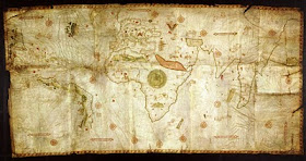
[2] Description: World map of the Portuguese cartographer Domingo Teixeira
drawn in 1573 with the sea routes of Vasco da Gama and Hernando de
Magallanes. Moreover the map shows the the meridian of Tordesillas, which devided the new discovered lands between Spain and Portugal.


[3] Description: World map made by the French mapmaker Guillaume Brouscon in 1543.


[4] Description: "Theatrum Orbis Terrarum" (Theatre of the World) made by
the Flemish cartographer and geographer Abraham Ortelius in 1570, who is
generally recognised as the creator of the first modern atlas.


[5] Description: World map made by Laurent Fries, woodcut 1522.


[6] Description: The Caverio Map (also called Caveri Map or Canerio Map) is a
world map drawn by the Genoese cartographer Nicolay de Caveri, circa
1505.

[7] Description: Orbis Terrarum published by the Dutch astronomer, cartographer and clergyman Petrus Plancius in 1594.


[8] Description: Map of the world 1552 by the Siebenbuerger Saxon humanist and Protestant Reformer Johannes Honterus.


[9] Description: "Orbis Terrarum" from the Dutch astronomer, cartographer and clergyman Petrus Plancius, published in 1590.


[10] Description: "A Chart of the World on Mercator's Projection", also known
as the Wright–Molyneux Map. This Map is the first world map produced in
England and based on the projection of the English mathematician and
cartographer Edward Wright.


[11] Description: World map of the Dutch explorer, cartographer, astronomer
and painter Johannes Ruysch published in 1507. Ruysch's work is the
second oldest known printed map showing the New World.


No comments:
Post a Comment